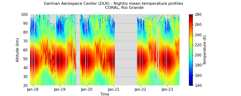
CORAL AMTM TELMA HELIX OP-LIDAR
| MON | TUE | WED | THU | FRI | SAT | SUN |
|---|---|---|---|---|---|---|
| 1 | 2 21:26 (13h39) | 3 | 4 | |||
| 5 | 6 10:43 (10h55) | 7 21:17 (12h33) | 8 21:32 (9h43) | 9 | 10 01:33 (10h30) | 11 21:25 (14h35) |
| 12 23:08 (10h36) | 13 | 14 | 15 | 16 | 17 | 18 |
| 19 | 20 | 21 | 22 | 23 | 24 | 25 |
| 26 | 27 | 28 | 29 | 30 |
Panel (a) emulates the measurement of a vertically staring ground-based lidar. Panel (b) shows absolute temperature profiles (ERA5: black, Lidar: red). Panels (c) and (d) are vertical sections of stratospheric T' along sectors of the latitude circle (c) and meridian (d) of the virtual lidar location. (e) and (f) are corresponding vertical sections of thermal stability N2 (10−4 s−2, color-coded), potential temperature (K, thin grey lines), and potential vorticity (1, 2, 4 PVU: black, 2 PVU: green) in the vicinity of the dynamical tropopause. Thin black lines in the vertical sections are zonal (d, f) and meridional (c, e) wind components (solid: positive, dashed: negative). Panel (g) is a horizontal section of the height of the 2 PVU surface (km, color-coded), geopotential height (m, solid lines) and wind barbs at the 700 hPa level. The black vertical line in (a) marks the current timestamp for (b)-(g) and dashed lines in (c)-(g) highlight the location of the virtual lidar and profiles in (a) and (b).
Publication archive - Rules of the Road for data usage - Impressum / Imprint - Datenschutzerklärung / Privacy Policy